Pourquoi Pas Island
Koordinatar:
| Pourquoi Pas Island | |
| øy | |
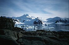 Pourquoi Pas Island sett frå Horseshoe Island | |
| Land | |
|---|---|
| Stad | Antarktis |
| - koordinatar | |
| Lengd | 27 km |
| Folketal | 0 |
| Administrert under | Antarktistraktaten |
Pourquoi Pas Island er ei fjellendt øy som ligg mellom Bigourdan Fjord og Bourgeois Fjord utanfor vestkysten av Graham Land. Ho vart oppdaga av Den franske antarktisekspedisjonen under Charcot, 1908-10. Øya vart kartlagd meir nøyaktig av British Graham Land Expedition (BGLE) under Rymill, 1934–37, som namngav ho etter ekspedisjonsskipet til Charcot, «Pourquoi-Pas?».
Sjå òg |
- Composite Antarctic Gazetteer
- Antarktiske og subantarktiske øyar
- Antarktiske øyar sør for 60 °S
- SCAR
- kravområde i Antarktis
Kjelder |
![]() Denne artikkelen inneheld stoff som er offentleg eige frå United States Geological Survey-artikkelen «Pourquoi Pas Island» (innhald frå Geographic Names Information System).
Denne artikkelen inneheld stoff som er offentleg eige frå United States Geological Survey-artikkelen «Pourquoi Pas Island» (innhald frå Geographic Names Information System).
|

